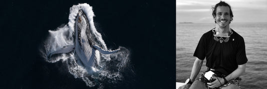
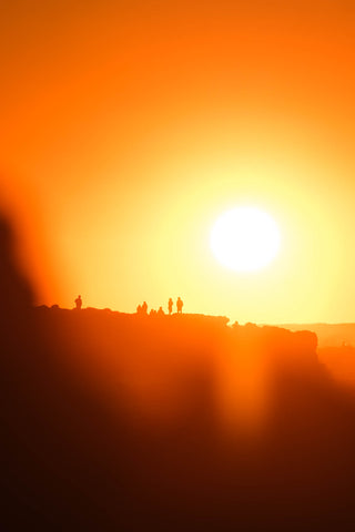
East to West | A Salty Journal
The Dream

|
 |
 |
In March of 2021 I decided to take a leap of faith and resign from my "day job"! I've worked in Marketing/Software Development since returning from my post-Uni travels in 2011 and wanted to get out of my comfort zone as a self-employed photographer and digital marketer. Who doesn't like the idea of remote work in Australia!?
Freedom
First things first, and with a new-found freedom that is rare in the modern world, I decided to plan a road trip to one of my favourite parts of the world, Western Australia. Since renting a campervan from Perth over Christmas 2017 I'd wanted desperately to return and dreamt of driving over from Sydney.
The Wheels
I toyed with the idea of driving over in my Mitsubishi Pajero (which is equipped with a bed) but decided to rent a camper instead to give me more room to work remotely and cook & chill away from the elements...not to mention the likelihood of a breakdown with my battered old wagon!
I managed to rent a hi-top camper from Sydney on a one-way agreement, meaning I could enjoy the journey out to WA, spend plenty of time there and then fly back when my month was done. The hi-top came equipped with everything I needed and provided ample space for me, my surfboard, free-diving equipment, and photography gear with room to spare.
I loosely planned a route that would see me cut straight through NSW, slice over the top of VIC and most of SA, speed across the Nullarbor and rock up in Australia's South West in just under a week. The plan then being to take my time working up the coast, trying to find as many pristine beaches, remote campsites and as much marine life as possible!
I was all set for the trip of a lifetime...
Day 1 | Bronte > Balranald, NSW
Distance covered: 853km
Total distance covered: 853km
Having picked up my home for the coming month the day before, I was planning on an early start to help smash out 10 hours of driving across NSW. Thanks to my delayed packing, last minute shopping and general faffing I didn't depart Bronte until close to midday, whoops!
A Wet Start
I had planned to stop in Wagga Wagga (5 hours from Bronte) for lunch (late, late lunch) but was feeling good so powered on through NSW in the sunshine. As the sun set, however, the heavens opened and I was left to drive for a further 4 hours in torrential rain! The toughest/scariest thing about driving in the heavy rain was weathering the tornado of wind and spray as land-trains pass in the other direction, so drive carefully.
I treated myself to a huge meal at a great Caltex trucker stop in Nandeera (highly recommended) along the way and arrived to stay at the perfectly appointed Balranald RV Parking site shortly before midnight. It was a fresh 5°C!
Day 2 | Balranald > Point Lowly, SA
Via: Mildura and Broken Hill Detour
Distance covered: 1,297km
Total distance covered: 2,150km
 |
 |
 |
Up bright and early to hit the road again, all in time for my first taste of COVID-caused disruption!
Mildura Detour
The A20 heading West from Balranald and on to South Australia via Mildura dips temporarily into the state of Victoria, meaning that any rules that apply to Victorian travellers would apply to me in SA and WA.
After consulting the WA border it became clear that I needed to avoid Victoria at all costs - they were still struggling with outbreaks and stricter border control applied to visitors of the state. I managed to chat with a couple of friendly locals in Mildura and decided the long detour north was a better shout than the old dusty track that skirts the Victorian border.
Broken Hill
That took me 2 hours north, to the mining town of Broken Hill, which is the picture perfect illustration of the Australian out-back painted in so many films (Mad Max was actually filmed in the town).
Although only passing the town for lunch I managed to visit the craziest old-school diner for some insane waffles (Bell's Milk Bar) and an old mine named Junction Mine for a quintessentially out-back scene. The whole town really has some magic!
After lunch I got stuck into the outback driving - heading east along the A32 - as I passed into South Australia and then on to Port Augusta. The endless dusty roads never got old for me and I loved clocking up the KMs across the vast, baron country.
Point Lowly
I ended up travelling beyond Port Augusta, pulling up for the night in Point Lowly, a destination famous for hosting an extraordinary cuttlefish aggregation. The camping was basic but free and I met a couple of keen snorkelers from Adelaide who were also eager to brave the cold and hop in the following morning.
Day 3 | Point Lowly > Fowler's Bay, SA
Via: Stony Point (Cuttlefish) and Whyalla
Distance covered: 626km
Total distance covered: 2,776km
 |
 |
 |
I only caught wind of Point Lowly (and the larger, nearby Whyalla) a couple of days before I departed after seeing some incredible footage of scores of mating cuttlefish. When I realised it didn't mean too much of a detour for me I was over the moon!
Giant Cuttlefish Aggregation
We got up shortly before sunrise and drove the short distance from the overnight parking to the cuttlefish site.
Given that the underwater world of Point Lowly is an internationally recognised marvel, hosting the largest aggregation of Giant Cuttlefish in the world, you'd expect it to appear protected and well-managed. It seemed to be the opposite, however, there is minimal fan-fare surrounding the cuttlefish (a few signs in a carpark) and the coastline is dominated by an ominous-looking desalination plant.
We waded out into the waist-deep, bitterly cold water and I plunged my head beneath the surface to start scouting. I've swam with giant cuttlefish in and around Sydney for years and it's always an exciting interaction, even though it's typically with individuals, occasionally pairs.
Their immense camouflage can make finding them hard so I was elated to spot one straight away in only 4-5ft of water. My sense of pride was short-lived, however, as I soon realised that there were dozens of giant cuttlefish littering the weedy, rocky bottom as far as the eye could see. Visibility wasn't fantastic but these amazing creatures were everywhere!
The aggregation revolves around their mating, so there's no shortage of entertainment as the cuttlefish run through their dazzling displays in the hope of attracting a mate. My 2mm wetsuit and the 15°C water meant the 45 minutes I managed in the water was no mean feat and even then it was hard to leave such a stunning scene!
If you're in the area between May & August you absolutely have to jump in! It's beginner-friendly snorkelling, right off the shore in the midst of an Attenborough worthy scene.
But after showering under my kettle to try and bring feeling back to my extremities I was on my way west again by mid-morning.
Back on the Road
The sun was out and the scenery stunning as I made my way on to Fowler's Bay via a pit-stop in the well-appointed town of Whyalla. It's a 7 hour drive culminating in a long bumpy track into the small town, which I managed to enjoy as the sun lit up the sky on it's way down.
Fowlers Bay
The town is tiny and was certainly sleepy. Arriving shortly after dark on a Thursday, the only sign of life was a friendly fella pitched up with his 4x4 and pizza oven trailer next to the pier. Thursday happens to be the only day of the week he's open for business selling pizza, he spends his time fishing otherwise. That worked out well for me and I enjoyed a delightful veggie pizza as the blood red moon rose out to sea.
The wind was howling and the temperature plummeting as I pulled up at the shore's edge for the night. There is a caravan park but it seemed to be closed for the evening and I was planning to leave early doors either way. I had no dramas and thoroughly enjoyed another night at the edge of the Southern Ocean.
Day 4 | Fowler's Bay > Moodini Bluff, WA
Via: Head of the Bight, Bunda Cliffs and WA Border
Distance covered: 552km
Total distance covered: 3,328km
 |
 |
 |
I woke to an absolute stunner of a sunrise over the jetty and took a couple of snaps before I hit the road.
With the sun shining and a vivid blue sky I thoroughly enjoyed the drive through the outback, regularly stopping to photograph the wildlife and scenery. Big flocks of Flaming Galah were common, as were scavenging Wedge-tailed Eagles, which are Australia's biggest bird of prey.
Wedge-tailed Eagles are apparently very susceptible to becoming road kill as it takes them so long to take flight when spooked from a road-side meal. The one above is tucking into an unfortunate wombat just outside Fowlers Bay.
Aside from petrol my first stop of the day was at the Head of the Bight, which is effectively where the Nullarbor Plain starts in earnest.
 |
 |
 |
Head of the Bight
The Head of the Bight seemed to be a popular stop for all and is made up of a visitor centre, facilities and insane views out to The Great Australian Bight. The Great Australian Bight is the large open bay that extends across the bottom of Australia.
The Head of the Bight offers (paid for) views along Bunda Cliffs to the west and back east to the white sands of South Australia. The blue waters and scenery are incredible alone but the real draw of the Head of the Bight are the Southern Right Whales that shelter along the coastline.
I was a little early to catch the migration in all its glory but still managed to spot a few distant whales enjoying the coast. If you're lucky enough to be passing later in the year (August - October) you're in for a treat! Be warned though, there is a strict no drone policy within the park.
Bunda Cliffs
Carrying on west from the Head you'll have three more opportunities to pull over and soak in the beauty of the Bunda Cliffs before you leave them behind! I did so twice but the wind prevented any drone flying - I also underestimated the ground I was covering and the cliffs were behind me before I knew it!
The cliffs are breathtaking; standing huge and dropping into the lucid blues below as far as the eye can see.
Border Crossing
Once you've passed the cliffs you'll hit the SA>WA border and, in my case, be glad that you skipped VIC!
Crossing the border was very smooth, be sure to sort out any approvals you need well ahead of time, and I was back on the road. It was also bizarre to be processed by a policeman from my hometown of Trowbridge at the border!
I kept trucking in search of Cocklebiddy but had completely lost signal at this point and didn't no quite where I was (it didn't much matter, there's only one road!). As the sun was close to setting I decided to pull into an overnight rest stop called Moodini Bluff (I discovered later) and cooked up some dinner before settling down for the night.
Day 5 | Moodini Bluff > Lucky Bay, WA
Via: 90 Mile Straight and Norseman
Distance covered: 787km
Total distance covered: 4,115km
 |
 |
 |
It was so perfectly quiet over night and waking up in the middle of nowhere felt pretty special.
As there was nothing around I carried on my way as the sun crested the horizon and started eating into the final leg before arriving in Esperance. Endless nothing-ness and Wedge-tailed Eagles would summarise the morning pretty accurately (I saw more eagles than kangaroos on the whole journey!).
90 Mile Straight
I soon arrived at the eastern end of 90 Mile Straight (as you might guess, a long stretch of road devoid of a single bend) and kept ploughing on towards my destination. The western end of the straight signifies that you're almost at the western edge of the Nullarbor.
Norseman
When you finally come to a junction of major roads you'll find yourself in Norseman, a medium-sized town complete with phone signal and shops!
I took the opportunity to check in with my fiancé Sadie and the family, having been essentially off the grid since leaving Whyalla (apparently Telstra customers can get signal along the Nullarbor, if you really want it!).
Esperance & Cape Le Grande National Park
After lunch I drove the remaining 2 hours south to the town Esperance. My destination was in the national park, a further 45 minutes from the town, and would leave me without power and phone signal once more. Given that was the case I took the opportunity to charge camera equipment in a local cafe before carrying on.
I ended up arriving into Lucky Bay Campsite shortly after dark, grabbed a shower and hit the hay! The weather wasn't looking to clever for the coming week so my 5 nights pre-booked was certainly in jeopardy.
Day 6 | Lucky Bay > Cape Le Grande, WA
Via: Lucky Bay, Rossiter Bay, Thistle Cove, Hellfire Bay and Cape Le Grande Beach
Distance covered: 12km
Total distance covered: 4,127km

|
 |
 |
Champions of Europe
My alarm was set for 4:30am to try my very hardest to somehow watch my beloved Chelsea in the Champions League final. I managed to get on a blurry Facetime with my friend Sam to watch us do the business, so the day started very well!
Lucky Bay
After a rainy night and a drizzly start to the day the sun started to fight back and, to my delight, burst through by mid-morning to light up the extraordinary, world famous blues of Lucky Bay.
The bay looked special under the grey clouds on my (bitterly cold) sunrise walk but it really came to life under the sun, especially as I had it all to myself (probably because no one else would be foolish enough to be walking along the beach in the cold rain at 6am!).
I took the opportunity to grab some snaps, especially in the knowledge that the weather was likely to turn before long.
Rossiter Bay
After a swim and a fly at Lucky Bay I took my van for a 4x4 adventure east to Rossiter Bay, which looked cool from the sky. In hindsight, though, the slow and bumpy trip was a waste of time - the bay was ugly and the water murky in comparison to Lucky Bay (I'm sure it was just a result of the weather conditions at the time).
Thistle Cove
Heading one bay west of Lucky Bay next I dropped into Thistle Cove, which was simply heaven on earth. The water was impossibly blue, the sand pristine white and there was barely a soul in sight. I droned and swam to my hearts content - revelling in paradise as the sun stayed strong for the most part of the afternoon!
Cape Le Grande & Hellfire Bay
I'd booked the next 3 nights in Cape Le Grande campsite so drove over to scope it out and grab a shower. The wind was howling onto Cape Le Grande beach and the water looked chopped-up and murky so I drove back round to Hellfire Bay. Hellfire Bay is on a par with Thistle Cove, absolutely stunning, but the rain started coming down again so I headed back to the campsite for the evening.
The campsite (much like Lucky Bay Campsite) is simple and well appointed. There are less bays available at Cape Le Grande, 95% of which were empty as a result of the weather forecast!
I whipped up my go-to dish of ginger, garlic & chilli chicken with greens, rice & quinoa in the van. Opting for a bigger van with an indoor kitchen was proving to be a masterstroke, it'd have been a pretty miserable evening without!
Day 7 | Cape Le Grande > Munglinup Rest Area, WA
Via: Day of Work in Esperance
Distance covered: 160km
Total distance covered: 4,287km
Rain
Rain, rain and more rain was the theme of the morning. I tried to sneak out for a walk from Hellfire Bay during a break in the weather...only to get caught in torrential rain and drenched through!
I also scoped out Frenchman's Peak for a walk but luckily caught a glimpse of the advice on a sign to avoid climbing alone or in adverse weather, both of which were very true for me!
Given that the rain was forecast to hang around for the next fortnight I made the decision to make a beeline for the West Coast, sadly skipping the magic of the South West.
Note: months later it became apparent that this was the right move, the rain had not relented for pretty much the entirety of winter!
Once I got as far as Esperance I pulled up to stock up and settle down to a day's work in the rain (I run a small branding/digital agency with my business partner as well as Salty Sea Dog).
Munglinup Rest Area
To get a bit of head start on the journey to Perth and grab a free camping spot I drove west shortly before sunset. I ended up pulling over at Munglinup to a perfect rest area for the night.
Day 8 | Munglinup Rest Area > Stirling, WA
Via: Cottesloe Beach
Distance covered: 601km
Total distance covered: 4,888km

|

|
 |
Off Roading
Well-rested and raring to clock up more KMs I set off for Perth shortly before sunrise. The 6 hour drive was made all the more interesting thanks to Google Maps' choice of route. At one point I was hurtling along an unsealed road for half an hour, caking the van in clay but getting a great view of rural Australia.
Cottesloe & Curry
I spotted my first pair of emus for the trip as I approach Perth and made it to Cottesloe Beach in perfect time for a dip and sunset! The sky had cleared up progressively as I'd travelled north throughout the day and the evening sun was a real blessing.
After drying off I made my way to Stirling to meet my friends Jules & Grete for the evening. They took my into Leederville for a delicious curry and kindly let me pull up at theirs for the night.
Day 9 | Stirling > Lancelin, WA
Sand Dunes & Sea Lion Swims
Distance covered: 119km
Total distance covered: 5,007km
 |
 |
 |
Being mid-winter, Perth was pretty much as cold as the south west and the morning temperature was around 6º. After sorting a few bits of admin for work I hit the road again, this time aiming for Lancelin, about 1.5 hours north of Perth.
I had heard Lancelin was a popular surfing spot but knew little of it otherwise. Arriving in the sunshine I instantly fell in love with the sleepy seaside town. The beaches and shallow waters are beautiful and the whole atmosphere was friendly, if a bit quiet.
North End Caravan Park
I decided to hang around for the night so checked into North End Caravan park, which is friendly, cheap and in an awesome location; about 1 minute walk from both the beach and. the sand dunes.
Back Beach & Edwards Island
I drove back to the south end of the town for the afternoon to snorkel off the Back Beach to a tiny island called Edwards Island. Although the water was beautiful there seemed to be little in the way of wildlife under water.
Meeting the Locals (Sea Lion Swims)
I swam across to Edwards Island and was just admiring the nesting Ospreys from afar when a friendly Sea Lion snuck up on me from the water!
The intrigued local seemed to be imploring me to join it in the water. So, very quietly & carefully, I got my gear back on and slipped back into the water.
The next 45 minutes were some of the most amazing of my life. The Sea Lion played with me with increasing familiarity, tracking me back to the mainland, darting in and out, rolling on the sea-floor and nipping at my fins! There was no one to be seen along the entire beach, save an old fella called Mike, who was walking his dog who said he couldn't believe his eyes!
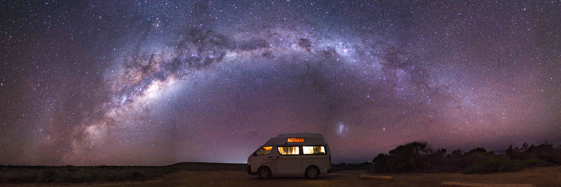
Stargazing on the Dunes
Dried off and fed I made the very short walk to the dunes for sunset. The towering dunes look out over the bay and really dazzle in the evening sunshine. I popped back to grab my tripod and traipsed back over the dunes to practice my astrophotography.
The moon had yet to rise and the sky was clear so conditions were perfect. It took a while to find the right spot amongst the endless blackness of the dunes but I managed to grab a couple of frames before getting too cold and sand blasted! At that point I just about succeeded in finding my way out of the dunes and back to bed!
Day 10 | Lancelin > Kalbarri, WA
Via: Hutt Lagoon (Pink Lake)
Distance covered: 458km
Total distance covered: 5,465km
 |
 |
 |
Cold Morning
I had my first "lie-in" of the trip thanks to the freeeezing cold morning before heading back up to the dunes and then on to the beach in the hope of finding my flippered friend again!
I had no luck in finding the Sea Lion although the local surfers said it'd been playing with them out beyond the island, so I'm sure it's a regular sight in that area!
Once dry and warm I packed up the van and set off just before midday, gunning to make Kalbarri by nightfall.
Pink Lake
One stop I was eager to squeeze in before reaching Kalbarri was Hutt Lagoon, also known as the Pink Lake. I arrived about an hour before sunset and pulled up to the viewpoint to launch the drone. The colours from the sky are far more dramatic than from the lake-side and the pinks were in great form.
I met a lovely couple (Claw & Nika) at the viewpoint and chatted for a while before getting back on the road to cover the last hour into Kalbarri.
Sleeping Under the Stars
I was treated to a vivid pink sunset as I pulled into Kalbarri, only to discover that all the campsites appeared to have closed at 6:30pm. With that being the case, I retraced my steps to the south of Kalbarri and darted down to a viewpoint to find a spot for the night under the stars.
I drove down towards "Natural Bridge" but pulled into a viewpoint called "Island Rock" just short of it and ended up staying put. It was just me and the stars on the edge of the ocean for the night, absolute paradise! Queue my second, and more successful, astrophotography attempt. This time stitching 21 slow shutter shots together to capture the Milky Way above the camper!
Day 11 | Kalbarri > Lyndon Rest Area, WA
Via: Pelican Feeding & Kalbarri National Park
Distance covered: 607km
Total distance covered: 6,072km

|
 |
 |
I pulled into "Natural Bridge" in the morning and was pleased to find facilities available - that allowed me to watch the sun rise over the water and start to take some of the chill out of the air! The wind was powerful and bitterly cold!
All of the viewpoints to the south of Kalbarri showcase their beautiful rock formations and dramatic seas - choose any of them to turn down and you can't go wrong, as long as you don't get blown away!
Pot Alley, Eagle Gorge & Natural Bridge are just a couple of the short walks. Keep your eyes peeled for giant Red Kangaroos and dolphins along the way!
I popped via the town and happened to catch the 8:45 daily pelican feeding, which takes place in front of the Murchison River Caravan Park.
Kalbarri National Park
The National Park was my next stop and the entrance is about a 10 minute drive from the town itself. Once in the park, you'll drive for another 20 minutes to the various car parks.
I parked up in a relatively empty car park to walk down to Nature's Window, the icon of the park. I had planned to take on a fairly long walk but much of the park and the walks were out of action after a cyclone passed through a month or so before my arrival.
I did a short walk along the ridge and returned to find huge queues for photos Nature's Window and a jam-packed car park so decided to make a getaway!
Heading for Coral Bay
The weather was looking grim for the coast for the next week or more but there appeared to be one last window of sunshine forecast for tomorrow.
With that in mind and as my walk was shorter than anticipated, I decided I had time to cover most the ground toward Coral Bay that day. Coral Bay was where I planned to finally stop driving for a bit and enjoy some slightly warmer weather, snorkelling and find some marine life!
7 hours later I pulled into Lyndon Rest Area, just 30 minutes shy of Coral Bay. I'd had plenty of reports that Coral Bay was at capacity - inundated with visitors who were unable to travel overseas due to the pandemic. As a result I'd booked 6 nights in hostel . Each of the caravan parks was fully booked (online at least) so this was my only option!
Lyndon Rest Area was a great free campsite to dip into for an overnight stop and I enjoyed another night under the starry sky (albeit with a few more neighbours this time!).
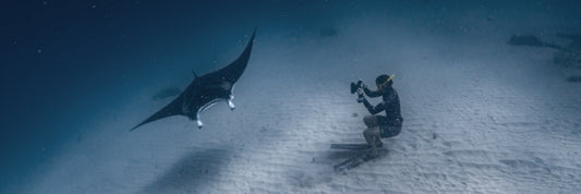
Day 12 | Lyndon Rest Area > Coral Bay, WA
Manta Tour on the Reef
Distance covered: 66km
Total distance covered: 6,138km

|

|
 |
Up before sunrise, I left the rest area and rolled down the hill to Coral Bay, keen to make the most of the sun and catch a sunrise before the rain set in!
I was just walking around from the main beach towards Skeleton Bay when I had a message from a friend Maxence (who had flown over from Sydney and recently arrived in Coral Bay) to say that there was a space on a manta tour with Coral Bay Eco Tours...departing at 7:45am that morning!
Given the imminent change in weather and limited capacity on tours at such a busy time I snapped up the opportunity and legged it back to the van, running over 1km at full speed across the soft sand.
I arrived just in time to register for the tour, grab my gear and hop on the bus!

|
 |
 |
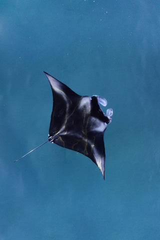
The late dash was so very worth it! The sun stayed shining, the visibility was supreme and the turtles, fish and mantas were out in force! The tour comprised of a snorkelling trip on the pristine coral reef, a visit to the mantas (and some surprise seahorses!) in the sandy shallows and one final snorkel at a turtle cleaning station among the stunning coral on the way back to the boat ramp.
I was even honoured with the chance to dive down in front of the manta on the last swim and get an ID shot! All-in-all a great, informative tour in one of my favourite places on earth.
 |

|
 |
The day wasn't over though - keen to make the most of the conditions, we jumped in for a snorkel at Main Beach and headed out across Lavender Gardens. The coral off the main beach is absolutely gorgeous; abundant and healthy, it made for a great swim.
Still not done for the day, I marched round Bills Bay to Skeleton Beach (to the north of Coral Bay) in the hope of capturing some mantas on the drone. I found some way off in the distance but I was losing light so finally called it a day!
Back round to the main beach for a big (and well earned) feed at Reef Cafe before retiring to the hostel for what turned out to be my worst sleep yet.
I decided the van was preferable to the pretty grim looking dorm room I was shown, so settled down in the Car Park. Unbeknown to me, the car park also turned out to be the venue for late-night, happy hardcore, car ravers!
Day 13 | Coral Bay, WA
Drizzly Rest Day
Distance covered: 0km
Total distance covered: 6,138km

|
 |
 |
Drizzly
Getting up and out of the car park feeling somewhat sluggish in the drizzle the next morning I thankfully managed to transfer the rest of my booking from the hostel to their campsite down the road.
I spent the afternoon working and then headed out for sunset as the rain has eased.
Manta Chase
I headed back to Skeleton Beach in search of mantas once again and managed to find them against the shore about 3km north.
Queue a mad dash across the soft sand armed with mask & snorkel. I ran and ran but the rain closed in again and the light dropped off so I had to call off the evening swim! I did bump into my friends Claw and Nika (from Hutt Lagoon), however, so was able to hitch a lift in their 4x4 back to the campsite!
I pulled together some burrito bowls for the guys as a thank you before hitting the hay for a much-improved sleep!
Day 14 | Coral Bay, WA
4x4 Adventures at Oyster Bridge
Distance covered: 0km
Total distance covered: 6,138km
 |

|
 |
Up early for a lovely sunrise over the bay and a morning drone flight in search of the majestic mantas (again!). Found them once more but they were too far up the beach to get to for a swim.
I'd arranged to join Claw & Nika on a 4x4 trip, aiming for Oyster Bridge, which is inaccessible to other vehicles and located just north of the town. They rocked up and met me shortly after 8am and we hit the sand in their 4x4 rental.
Dune-bashing our way to Oyster Bridge was super fun and opened my eyes to the opportunities that come with traveling in an all-terrain vehicle. We made it to Oyster Bridge and enjoyed a great snorkel in somewhat cloudy conditions but at least the rain stayed at bay!
Oyster Bay sadly brought an end for my GoPro Hero9 as it inexplicably flooded whilst snorkelling but that was the only downer on an otherwise great day! We even made it out in the 4x4, despite a couple of hairy (and hilarious) moments for the guys, who'd not taken it off-road previously!
Nika kindly whipped us up some dinner and then I grabbed a couple of drinks with Maxence and his friends Aurelie & Leo before retiring to the camper.
Day 15 | Coral Bay, WA
Snorkelling Five Finger Reef
Distance covered: 0km
Total distance covered: 6,138km

|
 |
 |
Another dark and drizzly morning meant I could crack on with some more work and charge up various batteries (I treated myself to a rare powered spot!).
Five Fingers Reef
The rain abated by mid-morning and a few of us set off for Five Fingers Reef, which is a decent walk from the boat ramp in Coral Bay. It'd. bean easy drive for a 4x4 but took about an hour walking around the jagged coast.
The reef offered some interesting snorkelling but conditions weren't great. The highlights of the snorkel were an inquisitive little cuttlefish displaying an array of colour changes and a vibrant nudi (sea slug) among the weed.
The rain returned for the afternoon and evening - so more work and reading ensued before bed.
Day 16 | Coral Bay, WA
Day of Work in the Pouring Rain
Distance covered: 0km
Total distance covered: 6,138km
Very little to report other than a productive day for my Digital Amigos clients and another day to be thankful for the comfort of my van!
I've rarely seen rain like it - Exmouth, to the north, saw an entire year's worth of rain fall that night!
Day 17 | Coral Bay > Osprey Bay, WA
Via: Exmouth, Heavy Flooding and Cape Range National Park
Distance covered: 231km
Total distance covered: 6,369km
 |
 |
 |
Earlier in the week I'd managed to snap up a night's camping at Osprey Bay in Cape Range National Park, which was no mean feat given that it was being shown as fully booked for months and months every time I checked.
Trapped
With the extraordinary amount of rainfall that had fallen overnight it was always going to be an interesting journey from Coral Bay, via Exmouth.
I left Coral Bay at sunrise and the rain was easing as I approached Exmouth but the roads were in a real mess and only getting worse. The flood water was rising and rising on parts of the road, full of debris and tearing the road apart in some places.
I made it into the town without any issues and met with a few friends from Sydney, the lovely Rosannah, Becki and Christina, for breakfast.
The plan was to head on to Cape Range for the day to explore the coastline but it became apparent pretty quickly that the flooding wouldn't make it easy! We were advised by the information centre that all roads in and out of the town were closed and we were effectively stuck in Exmouth for the time-being.
Cape Range Mountain Roads
As I'd recently arrived from the south I wasn't entirely convinced that this was the case so we decided it might be best to make a break for Coral Bay and, sadly, leave Cape Range for another time.
We made it out of the town easily enough and decided to head up into the mountains of Cape Range before carrying on south. The roads and views of the national park are sensational and well worth a quick detour if you're on this route! We drove as far as we could without 4x4s and bumped into my friends Claw & Nika again!
Amphibious Van
They advised us that the police had indeed closed the road north but expected to open it up at some point that morning. With that news, and eager to at least try to get to Osprey Bay, I decided to leave the girls (who were staying in Coral Bay that night anyway) and head north.
I timed it perfectly in the end as the road block was cleared for all vehicles shortly after I arrived. The first flood was deep but straightforward and I was on my way to Osprey Bay.
Only when I got a little deeper into the park did I appreciate the extent of the flooding. There were two parts of the road that had been torn up by the floods, one of which still held a vast, fairly deep expanse of flood water.
I was a little hesitant but relied on the decision made by the police and, more importantly, was able to follow an identical van through both!
A couple of nervy moments and I was into the national park! The sun started to shine through and I worked my down towards Osprey Bay.
Turquoise Bay & Osprey Bay
My first stop was Turquoise Bay and I pulled in for a lovely afternoon snorkel along the rip. Turquoise Bay is a popular spot and great for snorkelling but you need to be very mindful of the signs and observe the currents carefully.
The left hand side of the beach offers a gentle drift snorkel as far as the sand bank but you need to be immensely careful not to carry on any further as you'll end up being carried out to sea! The shallow coral and fish life was beautiful and the warm sunshine very welcome.
As the day had worn on I made for the campsite at Osprey Bay after drying off. Osprey Bay is one of my favourite places in Australia, perched right at the ocean's edge and beautifully disconnected from the world. The bays are spacious, the facilities simple and effective and the beaches, snorkelling and views are incredible.
I hopped in for an evening snorkel (again, please be careful of strong currents within the bays!) and was joined by cuttlefish, huge trevally and a host of other fish. I was a picture of contentment as I rinsed myself off at the van and settled down for some dinner after sunset.
Gutted to only have one night in this paradise but grateful for that night at the same time. Not a bad place to wake up on my birthday!
Day 18 | Osprey Bay > Coral Bay, WA
Via Sandy Bay, Oyster Stacks & Dugong on the Beach
Distance covered: 231km
Total distance covered: 6,600km
 |
 |
 |
Birthday Morning
There was a bit of rain overnight and I had to grab a few bits from outside the van. Luckily I'm in the habit of shaking out my towels, otherwise a giant millipede and a couple of geckos might've disrupted an otherwise heavenly sleep in my favourite campsite!
As it was, I was greeted by the sun as I brought in my 32nd birthday in style - enjoying breakfast as the sky came to life and opening cards from Sadie and my family.
Snorkelling the Bay
I was in the water just after sunrise, enjoying the turquoise shallows all to myself...aside from the white-tip reef sharks and multiple turtles! I jumped in at the northern point of Osprey Bay, effectively in Sandy Bay, and had to be very mindful of the strong current whipping around the point.
The wildlife were loving the clear shallows and the fast-moving tide. No fewer than 6 turtles and 3 white-tips were clinging on as the water surged past.
On my way back round I spotted a family in trouble closer to Osprey Bay itself so swam out and gave the youngest fella a ride in on my back.
All-in-all an awesome, if pretty exhausting, morning so I headed back to camp, had a rinse, grabbed second breakfast and got on my way.
Oyster Stacks
It's important to time your trip to the locally famous Oyster Stacks for a snorkel, as it's too shallow to do at any time save high tide. The coral was great and the sun continued to shine throughout the morning as the car park and beach got fuller and fuller!
Claw & Nika met me at Oyster Stacks and kindly brought me a birthday present of chocolate and a Ningaloo Reef mug, which was so unexpected and so kind of them!
I took them back to Sandy Bay in hope of finding the friendly turtles from the morning but I don't think the tide was quite right. There was plenty else to see though, including barracuda, clown fish and a huuuge cow-tail ray.
We went our separate ways after that and I headed back to Coral Bay once more - back to some form of civilisation, sadly. I did get to pass a dingo on the way back though, which was cool!
Walking the Dugong
I arrived back into Coral Bay about an hour before sunrise and decided there was time for one last birthday adventure! I drove round to Skeleton Bay in the van and flew the drone up over the shallows. To my delight it was there that I spotted a family of three dugong.
They were swimming my way so I ended up walking along with them, they were only 20ft from the shore but I thought better of swimming out them. Dugong are an endangered species and shouldn't be approached without a license, not to mention the fact that I was alone and it was getting dark, so swimming alone anywhere would be unwise!
I checked myself back into the campsite and popped out to join the girls at Reef Cafe for a big feed and a surprise brownie cake! We popped down to the Main Beach lookout to enjoy the starry sky before returning to the campsite and retiring for the night.
Day 19 | Coral Bay, WA
Salty Sea Dog Tours, Barrel Feeding and Ayers Rock
Distance covered: 0km
Total distance covered: 6,600km

|

|
 |
Salty Sea Dog Tours
Back in the paradise of Coral Bay and this time with a bright blue sky!
I made a beeline for the beach for sunrise and managed a couple of batteries worth of flights over the mantas in the shallows before the girls turned up for the inaugural Salty Sea Dog Tours! The plan was to find mantas in the shallows and swim out to them!
[Note: there are a host of great tour operators in the bay who run brilliant manta tours that almost guarantee interactions, plus snorkels on the coral reefs, food and unrivalled safety. I am a very strong swimmer and experienced snorkeller but still took every care]
My morning flights had shown that there were five or more mantas about 3km further up the beach (and one tiger shark a little earlier!) so we headed north with our gear, arriving at the spot just after 11am.
We didn't need the aerial support to find the black-winged beauties, their jet black shadows were visible from shore, as were the occasional wing-tip as they pivoted to retrace their steps.
The four of us hopped in as they passed, mindful to avoid disturbing their behaviour as we filed in behind them. The water wasn't anything like as clear as it appeared above but it was just incredible to get so close one of the most majestic creatures on the planet, especially when we could just jump in from shore!
 |
 |

|
Barrel Feeding
We waited on the shore as a couple of the tour boats came and went and then watched on as a couple of private tinnys sent in snorkellers a little further out. This tweaked my interest and I swam out to join them.
One couple out there happened to be an Instagram/photography friend called Lewis (@huntingforparadise) & his partner Tamsin and it turned out that there were multiple manta barrel feeding right beneath them! We revelled in the scene for a while before they dropped me back to shore.
The whole experience was incredible and a great way to launch (and wrap up) Salty Sea Dog tours!
 |
 |
 |
These photos of me were taken by Lewis (@huntingforparadise)
Ayers Rock
Not done with out day, we returned to the campsite and then kitted up again to swim out to Ayers Rock, a huge coral structure about 400m from Main Beach. It was unlike anything I've seen before and well worth a visit! The dive shops will be able to point you in the right direction and it's a pretty simple swim out.
Suitably tired, the girls treated me to a camper-kitchen feast before I retired to the van for a well-earned kip.
Day 20 | Coral Bay, WA
Tiger shark Tour with Ningaloo Marine Interactions
Distance covered: 0km
Total distance covered: 6,600km
 |
 |
 |
In between my adventures to Cape Range and Salty Sea Dog Tours I'd managed to book on to the famous Ningaloo Marine Interactions day tour to the reef.
Tiger Tours
The itinerary for the trip was much the same as the one I'd done previously but the tour is famous for being the only vessel on the reef to allow people to hop in with tiger sharks, which they actively scout out on the sand banks after lunch!
The coral snorkels and mantas were as brilliant as ever but the multiple swims with two different tigers really made the day! I'd been lucky enough to swim alongside these magnificent predators on the same tour back in 2017 but I don't think you could ever tire of it!
The experts on board check the temperament of the sharks and then position you to get a good view of the sharks to then turn and swim with. The sharks show little to no interest in the humans floating above them and carry on with their day but they are just so special to witness up close.
The snorkelling in between brought everything from turtles, to octopus, to black-tip sharks and clown fish in pretty clear water.
I got back in time to witness a beautiful sunset, watch England beat Croatia in the first game of the European championships and grab some grub before hitting the hay.
Day 21 | Coral Bay, WA
Day of rest
Distance covered: 0km
Total distance covered: 6,600km
 |
 |
 |
A few days solid of free-diving, running, swimming and adventures had left me in need of a rest day. Especially because I experienced a bout of vertigo and tinnitus that morning, suggesting my ears hadn't appreciated my free-diving attempts of the previous two days.
I took the drone up for a quick fly in the morning and was lucky enough to come across a beautiful turtle in the shallows and a lone dugong munching on the sea grass! The dugong was the perfect send-off for the girls, who were heading for Shark Bay, so I took the afternoon super easy and put my feet up with a book.
That was me for the day and I got tucked up in the hope that the vertigo would subside with some rest.
Day 22 | Coral Bay > Red Bluff, WA
Via: Bumpy, Dusty Tracks
Distance covered: 325km
Total distance covered: 6,925km

|
 |
 |
Leaving Luxury
Given that I was out of action with my ears and unable to snorkel, I thought it was the perfect time to leave the beauty of Coral Bay and start making my way down south.
After one last morning fly, I checked out of Bayview Campsite first thing and took the morning to fuel up, charge up and stock up with food before setting my sights on Red Bluff as my next stop.
I wasn't entirely sure where I should be heading next but had started to read up on Red Bluff after seeing a few photos of the surf from that area and thought sounded rugged and spectacular, which would be perfect after my extended, luxurious stop in Coral Bay.
Supposedly 3.5 hours from Coral Bay, the route to Red Bluff takes you south, almost as far as Carnarvon, before doubling back up on yourself and hugging the coast north.
Off-Roading
I called ahead to book into the campsite from Coral Bay (there's no signal for miles around at Red Bluff) and was assured that it was 2WD accessible. I guess, technically speaking, that was accurate but it took a lot longer than anticipated to bump my way along the dusty road to Red Bluff! The van shook like a leaf most the way, dust was being thrown everywhere and I needed a serious re-pack on arrival!
The road aside, the scenery along the road is absolutely out of this world! The sun was shining and the swell was pounding the shore as I made my way. For long, long stretches you'll be hugging the cliffs and there won't be a car in sight, it feels amazing! I even got a crazy cloud show as a thick bank of corrugated clouds loomed over me for the last hour of the drive.
First Impressions
The adventure in getting to Red Bluff made it feel that bit more special and, when I finally rocked up, I instantly fell in love with the place. I'd heard it was a great surfing spot but I have never seen a wave like it!
Big, pristine barrels formed at the south end of the headland, much to the joy of the line-up, who were absolutely shredding. I got the drone up and discovered that the mantas were keen to join the party too!
Sadly I didn't have much light to play with so I found myself a spot to park up and camp for the night. The whole site is very relaxed and it's up to you to find a patch that suits and is free.
It seems as though keen surfers rock up and camp for months at a time...and I can see why, it's real, raw Australia and a true surfers paradise!
Day 23 | Red Bluff, WA
Day trip to Gnarloo
Distance covered: 0km
Total distance covered: 6,925km
 |
|

|
Red Bluff Barrel
After an icy cold, ocean-side sleep I was up at the crack of dawn to catch the surfers at the point. The wind was howling but the sun was out and the wave was still firing (although slightly less than the previous evening). It was a photographers dream!
The line-up was already getting busy but everyone was super friendly, taking the time to chat and enjoy the morning scene.
Gnarloo
I'd been speaking to a lovely couple that morning, Marco & Annie, and they popped by the van to ask if I fancied joining them in their 4x4 to check out Gnarloo, another surfer's paradise just north of Red Bluff.
I hopped in and we made our way across the soft and bumpy tracks to Gnarloo, a trip I definitely wouldn't have fancied in the van (that said, there was another rental van parked up when we got to the break!).
Gnarloo was another sensational break, huge blue barrels crashing in over the reef time and time again and an incredible array of surfers carving them up.
 |

|
 |
Golden Hour
The evening consisted of more of the same iconic Australian scenes; barrels, mantas, beach-side camping and a glorious golden hour.
I was initially only planning to stay for the one night but there was no chance of that given the beauty of the place. So I managed to book in for one more and had enough food and water to make it work.
As the sun went down I whipped up a good feed and settled down under a blanket of stars. The beauty of being completely cut off with no power or phone signal is a complete sense of calm, that was only heightened by the location.
Day 24 | Red Bluff > Kalbarri, WA
Via: Quobba Station
Distance covered: 623km
Total distance covered: 7,548km
 |
 |
 |
Leaving Raw Australia
Wrapped up in my warmest clothes I braved the pre-dawn winds to visit the point again the next morning for the last time. I even climbed the bluff to get an elevated view.
The waves were still peeling and the mantas floating idly by as I soaked it all in before jumping in the van and sadly setting off. I had a lot of ground to cover so couldn't hang around.
I relatively flew back along the bumpy track with new found confidence. A bit of speed actually seemed to help ease the van across the corrugated track.
Quobba to Kalbarri
I had a brief stop at the blowholes at Quobba Station, which are very cool, but I didn't hang around as I'd visited them a couple of years prior. From then on it was back to real roads and on past Carnarvon to Kalbarri.
I rocked up in Kalbarri without incident and just in time for a much needed visit to the launderette! I also caught the sun setting from the foreshore and scoped out the impressive waves at Red Bluff (a different one!) and Back Beach before retiring to my powered campsite for the evening.
Ghost Stories
After dinner I was planning an adventure to Kalbarri Nation Park to get an astro shot of Nature's Window. My assumption was that there'd be a few photographers about given the perfect conditions.
However, on arrival to the park it was looking unlikely, there wasn't a soul around as I drove through the pitch black park, taking it slowly and giving the ghostly white eyes reflecting back at me a wide berth!
My complete isolation was confirmed when I arrived to an empty car park. The blowing wind, jet black sky and complete silence made for an eerie scene as I steeled myself for the short walk to the landmark.
Without phone signal or company I was trying to keep rational (something I normally excel at!) as I approached Nature's Window. At that moment, however, a haunting squeak, something akin to a rusty gate swinging, completely threw me off and had me running back to the car like Usain Bolt!
That was me done for the night and I drove back to civilisation as quickly as was safe. In hindsight I would've loved that shot and I was being completely ridiculous (it was hilarious at the time) but in the moment it was seriously spooky!
Day 25 | Kalbarri > Lancelin, WA
Via: Kalbarri National Park, Lucky Bay, Horrocks and The Pinnacles
Distance covered: 458km
Total distance covered: 8,006km
 |
 |
 |
Z Bend Walk
I had to get back to the national park first thing to at least get a sunrise shot after the failure the night before!
Having escaped the crowds as they began to swell again I drove round to the Z Bend walk. Advertised as a 2 hour return, it could probably be done in 20 minutes in reality but it's a beautiful walk in any case, especially as the sun started to take the chill out the air. The walk takes you down through the stunning red walls of the canyon and down to the water's edge.
Lucky Bay 2.0
I'd been chatting to the locals the night before and heard that Lucky Bay (in Kalbarri) was also an awesome spot to visit so I made that my lunchtime destination.
Not far south of Kalbarri you'll come to the Lucky Bay turn off and find yourself bumping your way along the unsealed road to a beautiful campsite nestled among the dunes - at this point 2-wheel-drives have no issue at all.
I parked up and walked out on to the beach (this is the point that only 4x4 suffice). The sands are endless and empty, save for the occasional passing Land Cruiser, and the north leads to a beautiful, protected reef - much like Oyster Bridge in Coral Bay.
On the Road Again
I pulled together some lunch in the van and hit the road again, continuing to my way south to pick Sadie up from Perth in a couple of days.
I stopped very briefly into the beautiful town of Horrocks for a pit stop and then powered down to the Pinnacles, arriving shortly after sunset.
 |
 |
 |
The Pinnacles
The Pinnacles are an extraordinary sight. The park is littered with these natural limestone structures, thought to have been formed 25-30,000 years ago.
I'd visited them previously but was keen to try out my new-found astrophotography skills on them. The moon was bright, meaning conditions weren't ideal for bright stars, but it certainly helped light up the foreground! Just look at how bright it was in the middle of the night!
With dozens of shots under my belt I carried on in the dark, deciding to aim for my trusty campsite in Lancelin. Most campsites seemed to be unmanned from 6-6:30 up the whole coast, so I figured I'd get somewhere familiar and settle up in the morning!
Day 26 | Lancelin > Perth > Jurien Bay, WA
Via: COVID-19 testing
Distance covered: 370km
Total distance covered: 8,3760km
 |
 |
 |
I was up early to get to work on making the van sparkle for Sadie's arrival later in the day. I pulled up by the beach in Lancelin to sweep the sand from every nook and cranny before carrying on my way to Perth.
I stocked up in the city and grabbed a few bits and bobs to celebrate Sadie's birthday! It was all going smoothly until COVID-19 reared it's ugly head again.
When Sadie took off in Sydney there was requirement to get tested to isolate on arrival. By the time she landed, visitors from NSW needed to get tested and isolate until they test negative on arrival.
This made for mad dash from the airport to the hospital to welcome Sadie to WA!
We queued for a couple of hours before Sadie was able to be tested and then hit the road at once. We were scheduled to be diving with seal lions in Jurien Bay the next day but instead it appeared as though we'd be stuck in the van waiting for this test result.
We finally got to Jurien Bay late on and had a bizarre birthday meal in the van. Even more odd was out night's sleep and self-imposed dehydration - limiting ourselves to relieving ourselves in the dead of night to avoid contact with anyone.
Day 27 | Jurien Bay > Overlander, WA
Via: Self-isolation!
Distance covered: 475km
Total distance covered: 8,851km
Our dehydration technique continued throughout the next morning as we held out for the test results before carrying on up to our destination, Shark Bay.
Our pain was eased, in a way, by the relentless rain that continued to pour down outside but we finally got the SMS through that we were all clear and hit the road at once...after plenty of water and a long overdue bathroom break!
Given the time we were unable to make it as far as Shark Bay but managed to pull into an awesome rest stop called Overlander, which is situated directly opposite the turning for Shark Bay. We parked up for a perfect night in the free campsite and had a great sleep.
Day 28 | Overlander > Shark Bay, WA
Monkey Mia
Distance covered: 154km
Total distance covered: 9,005km
 |
 |
 |
Blown Out
The rain eased up but the wind continued to howl as we pulled into the National Park. There are a few points of interest on the way in to the park, we stopped off at Shell Beach and Eagle's Bluff but neither were on great form in the strong winds and grey sky.
It was still fun to be road-tripping with my partner-in-crime and we pulled in to Monkey Mia for the afternoon. Monkey Mia boasts a state-of-the-art campsite, which was an absolute delight, but the big draw is the dolphin feeding. The dolphin feeding takes place daily on the beach within the park grounds but isn't something that interested us.
The sun came out to play and we strolled along the water's edge for the evening. It was about that time that we came to the realisation that what really makes the place special is Francois Peron National Park, which is inaccessible to 2-wheel-drive vehicles.
It was then that we started ringing around and managed to secure two spots with Wula Gura, who offer cultural tours into Francois Peron and could squeeze us on for the following day's adventure!
We whipped up some tasty grub in the brand-spanking new campsite kitchens and hit the hay.
Day 29 | Shark Bay, WA
Cultural Tour of Francois Peron National Park
Distance covered: 0km
Total distance covered: 9,005km
 |
 |
 |
Meeting Capes
Excited to be joining the cultural tour in Francois Peron, Sadie and I were up bright and early to head to the town of Denham. Denham is the main town of Shark Bay and the Visitor Centre there was our designated collection point.
Whilst waiting we met a few others who were joining the tour, which was dominated by a lovely group of 12 Irish girls who were living in Perth.
A little later than planned but in serious style, our guide for the day "Capes" rocked up in what was effectively a stretch Land Cruiser! He introduced himself and within 5 minutes it was clear that we were in for a great day; he was a man of the town, laughing and joking with everyone we met, full of beans and extremely quick-witted.
Darren 'Capes' Capewell is a descendant of the land's traditional owners and his passion and charisma even earned him the "Indigenous Tour Guide of the Year" back in 2006!
Red Dunes
Once we'd filled up with petrol we were on our way through the town, past Small Lagoon and into the stunning red sands of Francois Peron National Park. With Capes providing a narrative all the while, talking of his ancestral connection with the land and the stories of how it came to be, the land around you and the sights you see become draped in magic.
On entry to the park we let the tyres down before rolling down the rich red roads that dissect the park. I was honoured to have special treatment as the day's photographer and was even allowed to hop on the roof for a unique view. A couple of stops to learn about the plants and the animals of the land took us to the edge of Big Lagoon.
 |
 |
 |
Big Lagoon
At this point we were each given an Aboriginal name whilst preparing the kayaks for our next adventure. Sadie was "Gaya", which refers to the desert tree with leaves resembling an emus footstep. Appropriately, I was "Yallibirri", meaning emu.
The constant stream of information and depth of knowledge continued to enrich the experience, bringing me closer to truly understanding the land and developing a deeper appreciation for the aboriginal people.
With our aboriginal names circling through our heads, we set off in twos across the Big Lagoon. The going was pretty easy on the kayaks as we stuck to the shallows and avoided the strong winds.
We stopped a couple of times to take on board some more information about the land before arriving on the far side where we alighted on to the desert-red shore.
Once ashore we were taken on a walk among the dunes, finding out more and more about the magical connection between Capes & his ancestors and the land.
World Heritage
The place is simply astonishing, a rare destination where the red sands of Uluru meet the salt of the ocean. This means a unique combination of seabirds, land-birds, lizards and mammals converge in one environment. Consequently, Gutharraguda (Shark Bay) meets 4 of the criteria to allow it to be listed as a World Heritage Site, it only needs 1!
- Superlative natural phenomena or areas of exceptional natural beauty and aesthetic importance
- Outstanding examples representing major stages of earth’s history, including the record of life, significant on-going geological processes in the development of landforms, or significant geomorphic or physiographic features
- Outstanding examples representing significant on-going ecological and biological processes in the evolution and development of terrestrial, fresh water, coastal and marine ecosystems and communities of plants and animals
- Containing the most important and significant natural habitats for in-situ conservation of biological diversity, including those containing threatened species of outstanding universal value from the point of view of science or conservation.
The population of dugong is one of the factors that makes it such a special place. Unfortunately the dugong had departed the lagoon and much of the coast for the warmer waters of Dirk Hartog Island when we visited (mid-winter), however, 10% of the world's dugong population call Shark Bay home. A big reason for that is the fact that Shark Bay has the largest seagrass banks in the world, covering about 4,000 square kilometres!
After an hour or so taking in the scenery and meeting some of the locals (guitarfish and nervous sharks to name a couple) we made our way back across the lagoon and back into the Land Cruisers.
Hot Tubs & BBQs
The day wasn't done yet! After another drive back to the edge of the park we were treated to a delicious BBQ of kangaroo, fish & salad, which Capes and his crew cooked for us while we soaked in the parks natural hot spring!
When we were done there we were dropped back in Denham and made our way back to Monkey Mia via the friendly general store. As with much of the coast, you'll pay a premium in the little shops but there's little choice and I can't imagine the logistics that go into their stock! Aside from that it's always great to support the little man!
An evening stroll along Monkey Mia beach before another van-cooked feast and then bed.
Day 30 | Shark Bay > Jurien Bay, WA
Via: Geraldton
Distance covered: 629km
Total distance covered: 9,634km
 |
 |
 |
Due South
A day of travel was in store as we needed to start hot-stepping back to Perth for our flight the next day. We started with a slightly lazy morning at Monkey Mia before we packed up and hit the road, Jurien Bay bound!
We managed to catch our first emu on the way out of the park (the emus nest during June so we were lucky to spot one at all!) and stopped for a quick photoshoot.
We carried on down the highway, stopping only to refuel and enjoy lunch in Geraldton ahead of our arrival into Jurien Bay. This time we pulled up without needing to isolate and in relative sunshine, which was a nice change!
We enjoyed a pretty pink sunset and snuggled up to ward off the cold as we tucked up for the final night of the trip.
Day 31 | Jurien Bay > Perth, WA
Via: Wedge Island & Lancelin
Distance covered: 231km
Total distance covered: 9,865km
 |
 |
 |
The final day! After a month of the good life on the road it was finally time to drop it back in Perth and fly back to Sydney.
The adventure and drama wasn't quite over, however...
We awoke to another bitterly cold but bright morning in Jurien Bay and nipped to the beach to check it out. A quick fly out to the nearby islands in search of our Sea Lion friends was unsuccessful but was not in vain - the islands were absolutely stunning, little gems floating in lucid blue water.
It was at that time that we had a flurry of messages and email informing us that flights were being changed, cancelled, changed again, etc. etc. thanks to a blow up of COVID-19 cases in NSW over the past few days.
We eventually managed to both get booked on to a much later flight but on the same, meaning we'd land on the morning of our good friends' wedding in Sydney! It didn't change our plans too much as we still needed to get back and drop the van off!
Wedge Island
After some breakfast it was time to hit the road and continued south to Perth. Some of the coastline along the way looked absolutely stunning so we took a punt and ducked off the main road to a crazy little "town" called Wedge Island (I think!?).
The town is made up of a few slightly spooky looking summer shacks among the dunes that lead out to a sprawling white sandy beach. At the north point of the beach is the island, a spit of brilliant white sand leads out to it (we only saw this from the drone). We only had time for a quick beach stroll to scope it out and then carried on our way.
Lancelin
Prior to picking Sadie up from Perth I had dropped my surfboard off at the friendly campsite in Lancelin to make sure we had plenty of space for the two of us. We nipped into the town to collect it on the way back and took the opportunity to have once last Sea Lion search at my favourite spot!
Much like my second attempt previously, we had no luck but still enjoyed stretching our legs (and my drone propellers) along the gorgeous beach. I got some snaps of the breathtaking paddle out from above then we jumped back in the van for the last leg.
Big City Lights
We hit the traffic of the big city and managed to find a great little cleaning garage, keen make sure the van was up to standard for drop-off that afternoon.
We packed up our bags and got set for the flight, which was no small effort having been living out of a van for a month!
Dropping the van back was a breeze and we hopped in an Uber for the airport, where we'd have an 8hour wait for our flight!
Fairly safe in the knowledge that this flight wouldn't be cancelled we got ourselves comfy and reminisced on the magic of the last few days (and the drama!) and, for me, the month prior to that.
It's going to take me a while to get through all the footage and photos from the trip but, writing this, we've just entered our 3rd month of lockdown (which started the day we landed) in Sydney so I've had plenty of time at home!!
Thank you!
If you've made it through that entire account, thank you!! I'd love to hear your thoughts and let me know where you'd recommend for the next trip whether it's discovering more in WA or somewhere completely different!
Stay Salty,
Nick